

THE PRIMARY OBJECTIVE
Industrial Inspection & Data Acquisition
01
Utility Pole Inspections
Professional drone data capture for accurate, reliable utility pole inspections and asset assessment.
02
Telecom Cell Site Inspections
High-resolution drone data capture for safe, efficient telecom tower inspections and site documentation.
03
Wind Turbine Inspections
High-detail drone inspections for accurate blade, tower, and structural condition assessment.
04
Oil & Gas Methane Detection
Advanced drone-based methane detection for safe, efficient leak monitoring and emissions control.


RELIABLE DATA
Accurate Drone Data For Professionals
We provide professional drone-based data solutions for engineering firms, contractors, and property professionals. Every project is focused on accuracy, consistency, and real-world usability. Our data is designed to support inspections, documentation, and decision-making without complications
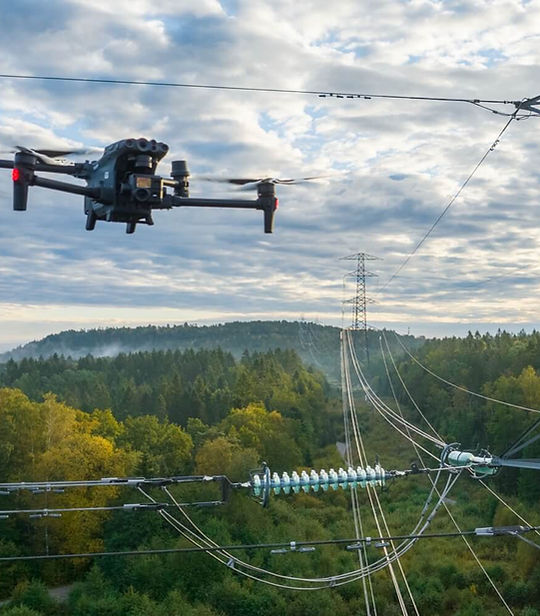
UTILITY POLE INSPECTION
Drone Data for Pole Inspections
Inspection-grade aerial data capture supporting utility asset management, condition assessment, and compliance workflows.
Swarm Drone Services provides professional drone-based data acquisition for both distribution and transmission pole inspections, delivering high-resolution, analysis-ready imagery to support utility and engineering teams.
Each flight is executed with a focus on capturing the critical details required for inspection workflows, including structural components, hardware, clearances, and surrounding conditions. Data is collected in a consistent and repeatable manner to ensure usability across modeling, assessment, and reporting processes.


TELECOM CELL SITE INSPECTIONS
Drone Data for Telecom Inspections
High-resolution aerial, civil, and LiDAR data capture supporting tower inspections, site documentation, and engineering workflows.
Swarm Drone Services provides professional drone-based data acquisition for telecom cell sites, delivering detailed aerial imagery, civil site documentation, and LiDAR data capture to support engineering and asset management workflows.
Drone operations provide a safer and more efficient alternative to traditional climbing inspections, capturing the critical details needed for structural review, equipment verification, and maintenance planning without disrupting site operations.
In addition to tower-focused imagery, flights are executed to capture civil site conditions, including ground layouts, equipment pads, access paths, and surrounding infrastructure. When required, LiDAR data capture can be performed to provide precise spatial datasets that support mapping, modeling, and site analysis.


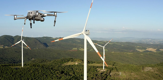
WIND TURBINE INSPECTIONS
Drone Data for Telecom Inspections
High-resolution aerial data capture supporting blade inspections, structural assessment, and maintenance planning workflows.
Swarm Drone Services provides professional drone-based data acquisition for wind turbine inspections, delivering clear, detailed, and analysis-ready imagery for blades, nacelles, and tower structures.
Drone inspections offer a safer, faster, and more efficient alternative to traditional rope-access methods, capturing the critical detail required for condition monitoring and maintenance planning—while minimizing downtime and operational risk.
Each flight ensures full coverage of turbine blades, including leading and trailing edges, surface conditions, and defect areas, along with nacelle and tower inspection data.


OIL & GAS METHANE DETECTION
Drone-Based Methane Detection
Aerial thermal and gas-imaging data capture supporting leak detection, emissions monitoring, and compliance workflows.
Swarm Drone Services provides professional drone-based data acquisition for methane leak detection across oil & gas pads and rig sites, delivering high-quality aerial datasets to support environmental monitoring, inspection programs, and regulatory compliance.
Using drone-mounted thermal and gas-detection payloads, flights are conducted to safely capture emissions data from elevated, hazardous, or hard-to-access equipment—reducing the need for manual inspections and improving site coverage
Operations are planned to provide both component-level detail and full-site visibility, capturing emissions indicators across wellheads, tanks, piping systems, and processing equipment. Data is collected in a structured and repeatable manner to ensure it can be effectively utilized by downstream analysis and reporting teams.


ABOUT US
Swarm Drone Services
Swarm Drone Services provides professional drone-based data acquisition for infrastructure inspections, construction projects, and local clients. We deliver clear, consistent, and analysis-ready data for telecom, utility, wind energy, and construction workflows, prioritizing accuracy and reliability.
Rather than generic aerial services, we focus on inspection-grade data capture designed to integrate into modeling, analysis, and reporting systems. We also provide reliable services for homeowners and businesses including roof inspections, thermal imaging, LiDAR capture, and aerial visuals.
Proudly operated by a U.S. Navy Veteran, bringing discipline, precision, and mission-focused execution to every project.