

4K
Quality Resolution
100+
Projects Done
6+
Years Experience
40+
Annual Events
Utility Pole Drone Inspections
Drone Data Collection for Distribution & Transmission Pole Inspections
Inspection-grade aerial data capture supporting utility asset management, condition assessment, and compliance workflows. Swarm Drone Services provides professional drone-based data acquisition for both distribution and transmission pole inspections, delivering high-resolution, analysis-ready imagery to support utility and engineering teams.


Telecom Cell Site Drone Inspections
Drone Data Collection for Telecom Cell Site Inspections
High-resolution aerial, civil, and LiDAR data capture supporting tower inspections, site documentation, and engineering workflows. Swarm Drone Services provides professional drone-based data acquisition for telecom cell sites, delivering detailed aerial imagery, civil site documentation, and LiDAR data capture to support engineering and asset management workflows.
Wind Turbine Drone Inspections
Drone Data Collection for Wind Turbine Inspections
Swarm Drone Services provides professional drone-based data acquisition for wind turbine inspections, delivering clear, detailed, and analysis-ready imagery for blades, nacelles, and tower structures. Drone inspections offer a safer, faster, and more efficient alternative to traditional rope-access methods, capturing the critical detail required for condition monitoring and maintenance planning—while minimizing downtime and operational risk.

.jpeg)
Oil & Gas Methane Detection (Pads & Rigs)
Drone-Based Methane Detection Data Collection for Oil & Gas Sites
Aerial thermal and gas-imaging data capture supporting leak detection, emissions monitoring, and compliance workflows. Swarm Drone Services provides professional drone-based data acquisition for methane leak detection across oil & gas pads and rig sites, delivering high-quality aerial datasets to support environmental monitoring, inspection programs, and regulatory compliance.
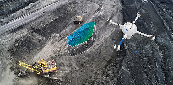
Construction Aerial Asset Management
Drone Data Collection for Construction Asset Management & Site Documentation
Consistent, time-stamped aerial data capture supporting project visibility, asset tracking, and documentation workflows. Swarm Drone Services provides professional drone-based data acquisition for construction aerial asset management, delivering clear, consistent, and time-stamped imagery to support project tracking, documentation, and asset visibility.

LiDAR Property & Interior Data Capture
LiDAR Data Collection for Property Mapping & Interior Documentation
High-precision aerial and interior LiDAR data capture—with optional processing and analysis support when required. Swarm Drone Services provides professional LiDAR-based data acquisition for property and interior environments, delivering accurate, high-density spatial datasets to support mapping, modeling, and documentation workflows.
Aerial Roof Inspections
Drone Roof Inspections for Insurance, Homeowners & Builders
High-resolution aerial data capture delivering clear, accurate roof condition imagery—without the need for ladders or manual inspections. Swarm Drone Services provides professional drone-based roof inspections, delivering detailed, high-resolution imagery to support insurance documentation, homeowner awareness, and construction quality control.

Real Estate Aerial & LiDAR Virtual Tour Package
Aerial Imaging & LiDAR Virtual Tours for Real Estate Listings
Showcase properties from every angle with cinematic aerial visuals and immersive interior LiDAR-based virtual tours. Swarm Drone Services provides a complete real estate media package combining high-resolution aerial imagery with interior LiDAR-based virtual tours—designed to elevate property listings and give buyers a true sense of space and layout.